Read in : தமிழ்
A debate is ongoing in media as well as in Supreme Court if Mullaperiyar Dam played a role in increasing the disaster proportions during Kerala floods this year. This debate is not about the safe water level in Mullaperiyar dam considering its structural safety, it’s more about the operational safety of dams.
Unfortunately, much of this debate is happening without key information about Mullaperiyar dam operation being in public domain, including about daily water and storage levels, daily inflows, outflows at various points and forecast valid for next few days. Why is the debate not about this information being in public domain on daily basis?
 Did Mullaperiyar dam release water while Kerala was facing floods? Yes. Could Tamil Nadu have reduced this flow? Yes. Let us see how. One sees following problems in Mullaperiyar Dam’s operations during Kerala floods.
- Mullaperiyar dam had already reached 90% of it storage capacity 173 MCM (Million Cubic Meters) by July 26. That should not have happened, till close to the end of monsoon. After filling up the dam like that, TN PWD that manages the dam would have no option but to release all additional inflows — a recipe for disaster for downstream areas.
Here it may be remembered that when the Supreme Court gave its order in May 2014 allowing TN to fill water upto 142 ft, it had set up a three-member supervisory committee with a Central Water Commission person as Chair. This committee should also be questioned as to what checks and balances they have put in place and why they allowed TN to fill up the dam before the end of the monsoon.
By accusing TN of unscientific reservoir operation of Mullaperiyar, Kerala could be accepting such a possibility for over 40 dams, many of them much larger than Mullaperiyar.
- In fact if we go by the CWC’s (Central Water Commission) weekly reservoir bulletin of 16 August, on that day the level was 147 feet, five feet above the allowed Full Reservoir Level of 142 ft, since CWC bulletin says FRL is 867.41 m and water level on Aug 16 was 868.91 m, that is 1.5 m or 5 ft above FRL.
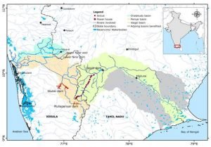
- Because of the above situation, Mullaiperiyar Dam was releasing so much water by August 14 night that water level at VendiPeriyar, on Periyar river just downstream from Mullaperiyar, not only crossed the HFL (the highest recorded flood level at this location), but went 3.5 m above it and remained above HFL for more than four days. The catchment area of Periyar at VendiPeriyar is 712 sq km, only marginally higher than catchment area of MPD at 648 sq km, so most of the water at this site could be seen to be coming from MPD.
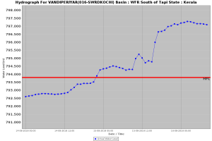
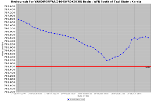 This unprecedented water levels at VandiPeriyar, downstream from Mullaperiyar in Kerala, is apparent from flood hydrographs of VendiPeriyar flood monitoring site of CWC, see below.
- The highest diversion capacity of Mullaperiyar dam to Tamil Nadu, if we go by what James Wilson, a Kerala official said, is 2,200 cusecs. There is no evidence that shows that Mullaperiyar diverted that much water say between July 20 to Aug 20. While power generation at MPD, which comes from water diversion, during this period was near maximum level, power turbines can pass a maximum of 1,600 cusecs. TN PWD needs to be asked how much water they diverted from Periyar on a daily basis during this period.
- It’s a mystery as to why TN waited till August 20 to release water for irrigation from Vaigai dam. Since water diverted from Periyar by MPD ends up in Vaigai Dam in TN, if water release from Vaigai Dam had started earlier, more water could have been diverted from Periyar. This would have benefited Tamil Nadu and less water would have flown to Kerala during the flood. TN also needs to answer as to why it did not start using water from Vaigai Dam earlier than Aug 20.
All claims of Kerala about Mullaperiyar Dam may not be accurate, and the claims in any case maybe like a self goal (since it means Kerala maybe guilty of the same fault of inducing floods due to unwise management of dams multiple times). Kerala had filled up all the dams by the end of July and then opened the gates of over 40 dams soon after the downpour started post Aug 8, 2018, thus increasing the disaster proportions significantly. By accusing TN of unscientific reservoir operation of Mullaperiyar, Kerala could be accepting such a possibility for over 40 dams, many of them much larger than Mullaperiyar.
However, TN may not be entirely above board. One only hopes that all concerned keep an open mind, learn lessons and make necessary changes in future. The first step in that context would be setting up an independent inquiry, both in Kerala and TN, about the role of dams in the current unprecedented flood disaster in Kerala.
Himanshu Thakkar responds to some of the comments this article has generated:
The article’s contention is not that no water was released from July 20 to August 20 to Tamil Nadu. The article does talk about power generation at the hydel plant that indicates flow but there is no evidence to say the maximum flow of 2,200 cusecs was sustained. I would like to see credible evidence from any official agency on this.
Regarding discharge from Mullaperiyar on August 14, please see the hydrograph for Vandiperiyar site (given in the article above). See how the water level went up and went beyond High Flood Level (HFL) at Vandiperiyar on the night of August 14. This figure is from the Central Water Commission (CWC). As I have said in the article, as per the official Water Resources Information Service (WRIS) report, 90% of the catchment at Vandiperiyar is upstream of Mullaperiyar. This means Vandiperiyar’s flood must have come largely from Mullaperiyar.
Some questions have been raised about apparent discrepancies in dam level data. On the CWC weekly reservoir level bulletin, Mullaperiyar’s Full Reservoir Level (FRL) is consistently given as 867.41 m (this level is above mean sea level, MSL). I assumed it corresponds to 142 ft (measured from foundation), which is the current FRL. I could not find in any official document the corresponding height above MSL for FRL 142 ft. I asked a colleague from Kerala, who has researched on Mullaperiyar Dam, but he also did not know. I assumed CWC must be giving correct FRL. CWC says in their bulletin that all the information in the bulletin has been provided by the respective state governments. If CWC is giving wrong information, it could mean wrong information is being supplied to it by the state governments concerned.
The article had said the level at Mullaperiyar, as per CWC figures, had gone above FRL by five feet. It is very much possible that the level at any dam can go five feet above FRL. There are several dams in India where the designated (which has been attained or breached) MWL (Maximum Water Level) is several feet above the fixed FRL gates. This level depends on flood level and gate position.
Read in : தமிழ்