Read in : தமிழ்
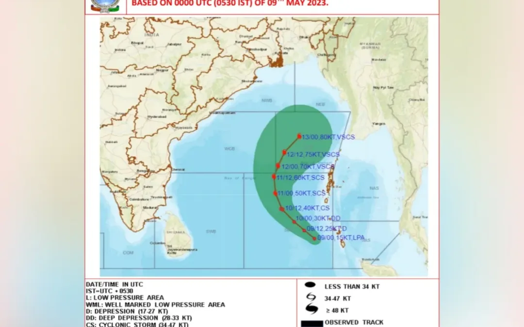
All the eastern coastal states are bracing themselves for the fallout of a weather system, dubbed Cyclone Mocha, which is slowly making its way north in the Bay of Bengal. The India Meteorological Department (IMD) on Tuesday said a well marked low pressure area already in the South Andaman sea was expected to intensify into a depression and later into a cyclonic storm.
This weather system, heralding the first extreme event ahead of the 2023 Southwest Monsoon, is part of the annual cycle of extremes that hits the eastern coast of the subcontinent. According to the IMD, heavy rainfall could pound parts of Tamil Nadu, Puducherry and Karaikal among other places, as the course of the weather system becomes clearer. On Tuesday, the IMD said Mettupalayam received 9 cm of rain, while Virudhunagar and parts of Kerala’s Idukki district got 7 cm each. There were other places that received heavy rain in both states.
A forecast put out by online weather monitor Windy estimated that the weather system as of Tuesday would intensify into a storm and move north in the Bay, covering the Andaman islands by midweek, after which it was expected to recurve in a northeasterly direction towards Bangladesh and Myanmar. Updated forecasts would be necessary for a more accurate picture over the next few days.
Pattern of cyclones
Research literature shows that there are two peaks of tropical cyclones that hit the coastal states in a year, representing the period before and after the monsoon. While the pre-monsoon (April-May) phase has an average of 11 tropical cyclone days, the post-monsoon (October-December) peak has 18 days. Significantly, although the Bay of Bengal represents only 5% of cyclones worldwide, its rim countries account for 80% of fatalities, according to data. The Arabian Sea has started facing a higher occurrence of cyclones in recent years, while the frequency has stalled in the Bay.
The India Meteorological Department (IMD) on Tuesday said a well marked low pressure area already in the South Andaman sea was expected to intensify into a depression and later into a cyclonic storm
The nascent weather event in the southern Bay, dubbed Mocha as proposed by Yemen to the World Meteorological Organization, is forecast by the IMD to develop wind speeds of over 80 knots (148 kmph) on Tuesday, putting it in the category of a Very Severe Cyclonic Storm (VSCS) at present. Much of the bay has been declared a “no fishing” area for the duration of the system.
The IMD has forecast thunderstorms, lightning and gusty winds in Kerala and Mahe over a five-day window from Tuesday, while Tamil Nadu, Puducherry, Karaikal and coastal Karnataka could experience isolated heavy rainfall, along with parts of northeastern States.
Also Read: As rain clouds appear, Chennai fears Mandous sequel
What is of interest for the future is the performance of the incipient weather systems over a period of time. Researchers Chirag Dhara and Roxy Mathew Koll said in an article in The India Forum, that recent cyclones such as Ockhi, Fani, Amphan and Tauktae had rapidly gathered in strength, even in a single day, and intensified into ‘very severe’ status, causing greater damage.
The role of global warming and climate change is being investigated here, as studies point to rapid intensification of weather events when the oceans are warmer. Here again, the temperature to a depth of 100 metres has an impact on the intensity of the cyclone, with higher temperatures linked to greater intensity.
El Nino shadow
In 2023 and 2024, the likelihood of an El Nino altering the temperature patterns both on land and at sea will be keenly watched. Climate scientist James Hansen and his colleagues have proposed that 2024 could be the hottest year ever recorded with a clear imprint of El Nino.

(Photo credit: IMD)
As altered climate patterns bring about greater intensification of weather events and the number of times they occur in a year, coastal states including Tamil Nadu have to focus on adaptation of coastal communities to such extremes. Several decades ago, the response of the state was to build circular cyclone shelters in the coastal districts, which were later turned into Sri Lankan refugee centres when the ethnic crisis broke out in the island.
Cyclone Mocha is forecast by the IMD to develop wind speeds of over 80 knots (148 kmph) on Tuesday, putting it in the category of a Very Severe Cyclonic Storm (VSCS) at present. Much of the bay has been declared a “no fishing” area for the duration of the system
Today, there is greater emphasis on better scientific modelling to provide early warning alerts to help save lives and property. Prof Koll points out that the basics are better understood today, although closer linking of ocean temperatures with storm intensity and movement is still evolving.
The uncertainties also point to the sub-prime nature of real estate along the coastline being sold for massive sums through high-voltage marketing. These communities would be in the first line of impact as storms intensify.
Also Read: Asani: More powerful cyclones are now a year-round challenge
The Tamil Nadu government, which has created a separate departmental framework for climate change within the overall umbrella of environment should resolutely address future storm impacts and sea level rise with the goal of increasing resilience and assessing risk scientifically.
Read in : தமிழ்