Read in : தமிழ்
World Environment Day is a good time to take stock of how infrastructure in Chennai has developed historically and what its impact on ecology has been. This will help to plan for developing infrastructure in Chennai in future.
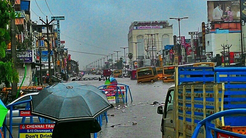
Chennai, which lies along the coast of Bay of Bengal, is prone to annual cyclonic storms between September and December. Records show frequent storms and flooding in the city. However, the 2015 deluge was disastrous.
Many researchers said the deluge was ‘man-made’. But a study claims that it was due to systematic encroachment of lagoons, wetlands, and tanks of Chennai. “The flow of water from larger tanks to smaller ponds to the ocean was blocked. The satellite image of Chennai proves this. Climate change is not the only guilty party. The scale of the disaster at Chennai was magnified by a rampant disregard for town planning, and the basic principles of ecology and hydrology,” said Xavier Benedict, a leading architect in his research paper titled “Urban Form of Coromandel Region – a Case of Chennai: The Institutional Hindrance of the Commons and Anticommons.”
The international airport is built on the floodplain of the Adyar river; the Mass Rapid Transit System sits atop the Buckingham Canal; the government allowed buildings to be erected over more than 273 hectares of the marshland to the south of the city that would normally act as a sink for flood water.
Chennai stretches nearly 31 km along the sea coast from south to north, with a maximum width of 22 km on east to west. “This gave way for the establishment of five radial roads from the founding of the city by the British, and followed by suburban railways expanding the city in a semicircle,” says the study, published recently in “Cities as Assemblages”, a collection of proceedings of the International Seminar on Urban Form held in Cyprus in 2019.
Chennai has many roads called ‘high-road’ – Nungambakkam high road, Kodambakkam high road, Ponnamallee high road, Tiruvallur high road etc. These roads were raised from the swampy wetlands and paddy fields by filling. Hence, the word high-road came to origin
The city of Madras was the first properly chosen site for the capital of power by the British East India company in 1639. There were significant reasons behind it. “The city has the sea as a boundary and naval establishment. The roads and canal-navigation as strategic routes to connect with the hinterlands for trade and commerce. Later with the development of railways the power of the establishment became far more extended to bigger territory. In India, Madras (Chennai) was the most advanced and first in all scientific and industrial establishments. This gave rise to development of town-planning, urban engineering, and surveying technology,” it says.
The colonial city’s form and functions became a direct reflection of its foreign origins, and as such it represented the microcosm of the larger colonial empire of which it was a product. “In 1639, after several abortive attempts to establish factories on the Coromandel Coast, the East India Company chose a site south of the town of ‘Madrasapattinam”. The region was a rich cotton and rice growing country laced with lagoons and rivers that were capable of supporting an expanding population. In 1653, Madras was made a Presidency and five years later all English settlements on the Coromandel Coast and other regions of the sub-continent were subordinated to it,” says Xavier Benedict in his study.
The houses of the Britishers and its naval officers are placed inside the first fort. And business communities from other European nations and Indians are placed in Black Town. The streets of Black Town were laid out on a grid and the houses were built of brick with thick walls to insure coolness in the summer heat. “From the mid-18th century, Europeans began moving out of the Fort and Black Town into newly developing garden suburbs. Substantial portions of the urban landscape were dominated and annexed by the colonials. The banks of the Adyar and Cooum Rivers were areas sought for the construction of garden houses,” he said.

The Buckingham Canal atop which the Mass Rapid Transit System sits in Chennai
Historically, says Xavier, Madras evolved from and around the British trading post. The annexation of various self-sustaining villages during 18-19 Century CE had a significant impact on its urban morphology. “The colonials dictated the morphological form that Madras would take by demarcating certain areas of the city for particular occupational purposes, and by settling migrants in colonies according to their economic skills. This segregated themselves from the indigenous inhabitants, and the new neighbourhoods followed western models of design, expanding laterally and replicated land use without vernacular principles,” he added.
Chennai has many roads called ‘high-road’ – Nungambakkam high road, Kodambakkam high road, Ponnamallee high road, Tiruvallur high road etc. “Chennai is the city in India to have more than 20 high-roads. The Britishers constructed a road connecting various villages during the process of annexation. These roads were raised from the swampy wetlands and paddy fields by filling. Hence, the word high-road came to origin. A closer look on the historical maps we would find high roads crisscrossing with culverts on the paddy fields for motor vehicles to pass,” says the study.
The Long Tank was a natural lake which was situated on the western frontier of the city Madras. Comprising two sections – the Mylapore Tank to the south and a feeder lake Nungambakkam Tank to the north — it extended for about 8 sq. km from Sterling Road in the north to the suburb of Saidapet in the south. About a mile in width, it formed the boundary of Madras city as well as the district till 1921. “With the city’s population growing from approximately 398,000 in 1871 to 527,000 in 1921, the British decided to reclaim the Long Tank to support its population. The Mambalam Housing Scheme was mooted by the Town Planning Trust in 1923 and approved by the Municipal Corporation. Long Tank was incorporated into the city and by the 1931 Census was added to the city,” it said.
Reclaiming tanks and lakes to accommodate the population became the norm. “Every waterbody was claimed by the government agencies to accommodate the population. The configuration reflects a new urban form India. The form that reflects the European character of separation of work and house. The ideology of individualism clearly reflected which was absent in the traditional settlement,” says the study.
Chennai is traversed by three major rivers namely Kosasthalaiyar, Cooum and Adyar. “The Cooum collects surplus from about 75 rain-fed tanks and Adyar river collects surplus from about 450 tanks in its catchments, apart from overflows from the Chembarambakkam tank. The flood discharge of Adyar river is almost three times that of the Cooum. More than 600 tanks, which includes temple-tanks, drinking and irrigation tanks were present in the city till 1909 as per the Madras irrigation department. These tanks were naturally profiled to catch water flowing along the slope towards the sea. They were very very effective during the non North East monsoon months,” it says.
The study, according to Xavier, was conducted to understand the importance of regional factors which would directly impact the character and features of urban conglomerates. After the December 2004 tsunami that hit the south-east coast of India, there has been recognition among coastal communities living adjacent to coastal sand dunes about the value of these habitats in protecting the hinterland and coastal hamlets, and their role in preventing saltwater intrusion as a result of inundation by large waves. “The 2015 Chennai deluge made us realise the linkage between nature and culture in urban morphology. The two rivers which carry excess water are overflowing as they do not have adequate capacity to discharge into centuries-old canals and tanks. It made us look into topographical and hydrological study on urban form. A further study and analysis would throw up brighter ideas on the subject,” said Xavier. “There is a correlation between nature and urban form. It clearly needs further deliberation for developing native urban design principles. Particularly, the climatic condition, linguistic culture, and natural habitat of a place influences the urban form,” he added.
Read in : தமிழ்