Wayfinding is part of global travel culture but in India it poses a serious challenge. Even in the era of national job mobility and a post-COVID tourism wave, governments don’t make it easy for people to find public places and essential facilities even in the biggest cities. Indian politicians are keen to provide clear pointers only to the next election. Maps online provide some guidance, but have nothing to say on the conditions on the ground.
Try finding your way from Bengaluru’s bustling Majestic Namma Metro station to the City Railway Station just 200 metres away across the road. For a start, the traveller has to be alert, determined and physically able to quickly get to the rail terminal. Sorry if you have heavy bags.
As a software megapolis that has been at the centre of a construction boom for two decades and hosts tens of thousands of people arriving from various parts of the country, there must be clear wayfinding signs to and from Bengaluru City station. But then, Indians generally don’t like to put useful things down in writing, including wayfinding signage.
As you step out of the Metro train at Nadaprabhu Kempegowda Station Majestic, there are signs on the platform and in the concourse, giving Exits A, A1 as the way to the “Indian Railway” and KSRTC/BMTC bus terminal side. Follow these signs, and you cross the turnstiles and enter a long passage that connects to the Majestic bus terminus (Kempegowda Bus Station), and, a sign says, the Indian Railway.
As a software megapolis that has been at the centre of a construction boom for two decades and hosts tens of thousands of people arriving from various parts of the country, there must be clear wayfinding signs to and from Bengaluru City station. But Indians don’t like to put useful things down in writing, including wayfinding signage
All is well until you enter the passage and go towards the bus terminus. Suddenly, there are no more signs, and you find yourself walking towards a dark, dirty elevated walkway that takes you to the railway side (more puzzles lie in wait there). There are two dead lifts at either end of the elevated passage, their walls grimy and dirty and the flooring full of slush after a little rain. Again, if you are not fit, able, determined, oblivious to stink and dirt, it is impossible to carry your bags up and down the walkway, so hiring a vehicle to reach the other wide is the wiser option.
On the railway side, there is further confusion. You cannot find any more indicators on which way to proceed to the station. A few would discover a small entry into Platform One from a parking area and closed ticket counter, while others would have to ask around and trudge to the main entrance which is encircled by autorickshaws, shops and stragglers, the view obscured by a visual soup of commercial messages and typically Indian chaos.
Also Read: A grand Chola museum may bring tourism infra to Thanjai
Google Maps says you would be able to cover this walk from Majestic Metro to the City railway station in about 7 minutes, which is overly optimistic. It does not immediately convey that there is an up and a down component to this trip.
These pictures tell the story from the night of May 19.

The ground-level entry on the main road linking the Nadaprabhu Kempegowda Metro Station Majestic lies shuttered. Photos by the author

The lifts on the elevated walkway from Majestic Metro station, Bengaluru are plainly dead
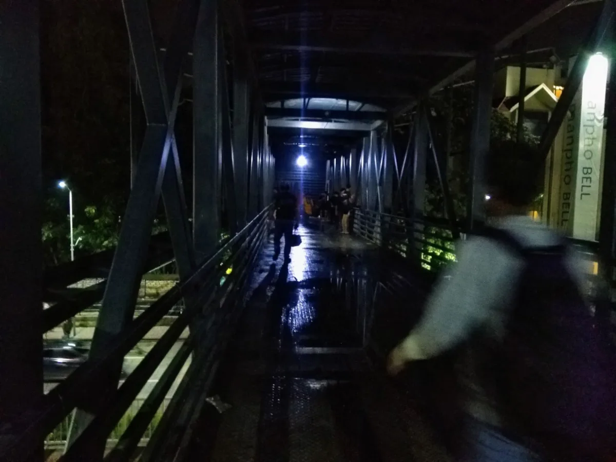
The dark elevated passage from the Metro and Bus Stand side to the City Railway Station in Bengaluru with stagnant water on the floor after rain.
Many millions may be spent by the Union government and the Railways to put in some meagre facilities in old, antiquated rail terminals, as part of the Amrit Bharat Station scheme, but there is still no way to easily navigate to the station in Bengaluru.
This is a typically Indian problem, since people generally don’t look for signs (some of them may be hopelessly outdated or confusing), and prefer to “ask someone”. The bureaucrats in-charge of providing facilities and signage have little need for information signs, as they do not normally walk to these places.
Karnataka’s Congress government led by Chief Minister Siddaramaiah and Deputy CM D.K. Shivakumar could intervene with a small but effective set of measures to make things better:
- Install at least four powerful high mast lamps on the main road where both SBC-City Railway station, the Nadaprabhu Kempegowda Majestic Namma Metro station area and the KBS terminus for buses. This would brighten the passage infinitely and make travellers feel safer.
- The walkway from the Metro station to the City railway station should be disabled friendly with lifts, and escalators for general population. There should be no need to go up and down a flight of stairs and walk on the heavily encroached road to reach the Station. The walkway could also similarly connect the bus terminus.
- Even if there is a similar facility elsewhere in the area – and it does not reflect in the Metro signage – there should be more elevated walkways with bright lighting and escalators for easy mobility.
- Provide a colour-coded walking path to the City Railway Station and bus station, with illuminated Indian Railway/KSRTC/BMTC logo used prominently and frequently, and use similar colour coded LED lights for night movement. Make things brighter.
- Clean up the area by removing garbage, and provide public conveniences to stop people urinating in all dark corners.
- CCTV is necessary on all sections of the passage
- Designate a demarcated area for autorickshaws to stop the crowding at the entrance and exits to the rail terminal, which gives it an appearance of unmitigated chaos.
- Put in a new pedestrian subway that is easier to use, with escalators and lift facilities to cross the Gubbi Thotadappa Road which has been fully median-fenced to prevent pedestrian crossings. People coming by Metro and buses have an equal right to easy passage across the access road to the City station as do car users, in such a busy transit hub in India’s Silicon City.
Many millions may be spent by the Union government and the Railways to put in some meagre facilities in old, antiquated rail terminals, as part of the Amrit Bharat Station scheme, but there is still no short way to easily navigate to the Bengaluru station on foot
There are examples of clear signage transforming the way visitors and residents engage with the city, and one that is cited by the urban planning initiative is Kochi Ithile, which uses carefully designed signage strategies on the ground and online information systems to help walkers. Smart City money also provided some cities, including Chennai, with resources to put up road signage giving street names. Yet, almost everyone has done a poor job of making wayfinding an efficient and pleasurable exercise.