Read in : தமிழ்
Nilgiris is teaching the rest of Tamil Nadu some lessons.
The storied monsoon that has inspired weathermen, poets, writers and nature lovers defines much of India in many ways. It used to define Tamil Nadu too by leaving the state out barring bright showers up in the Ghats and Nilgiris. Not this year though.
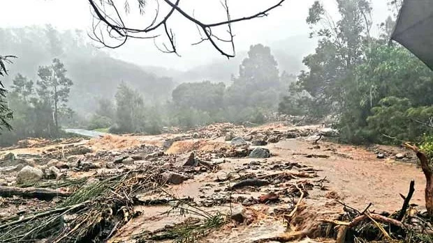
The monsoon seems to be changing and it looks like Tamil Nadu will very much be part of the Indian monsoon going forward. The ecologically-sensitive hill districts of Nilgiris and adjoining Wayanad in Kerala have been battered by torrential rains this year — almost double of last year’s rains. Local bodies and the district administration have now to consider putting in place measures to prevent / manage natural disasters such as landslides and flash floods. Though the south-west monsoon has subsided, the north-east monsoon is in the offing, and gauging, monitoring and analyzing changing weather patterns of the region is crucial to prevent loss of life and property.
According to data from the Agro Climate Research Centre of the Tamil Nadu Agriculture University (TNAU), for the period June 1 – Sept. 6 this year, Tamil Nadu received unprecedented rainfall, recording a 99% increase over the normal. Nilgiris district received the highest rainfall of 1,752 mm. The adjacent Wayanad district, which is also part of the Nilgiri Biosphere also received heavy rainfall of 1,587 mm for the period compared to 1,389 mm last year(2021).
Experts including climatologists and soil conservationists have warned of the likelihood of natural disasters like landslips, piping (land caving in as a pipe in particular areas) and flash floods at various spots in the slopes of Western Ghats of Nilgiris district similar to the devastating landslides in Wayanad over the last two years. In June 2020, flash floods wreaked havoc in Nilambur town on the banks of the Chaliyar river, which originates from the Elambileri Hills in the range.
Though the south-west monsoon has subsided, the north-east monsoon is in the offing, and gauging, monitoring and analyzing changing weather patterns of the region is crucial to prevent loss of life and property
Later it was established that the incident was the sequel to a landslide in the forest region near Devala in Gudalur due to heavy rain that lashed Gudalur and Pandallur taluks of Nilgiris . Though the landslide took place early during the day, the water reached the town past midnight. Houses, shops and streets were submerged and people were caught in their sleep as the catastrophe engulfed them.
The soil structure of the Western Ghats regions has undergone severe changes due to human activity, and extreme weather events triggered by climate change resulting in extensive damage. In a double jeopardy, all the rivers originating from the Nilgiris ranges, including the Bhavani, Noyyal and Amaravathi, still have strong water flow as their catchment areas are still getting good rains.
Also Read: Chola irrigation plan helps to revive waterbodies in Coimbatore
The Noyyal originates from the Western Ghats and flows through many villages of Coimbatore and Tirupur before joining the Cauvery river. Hence any instance of excessive rains in the Ghats is likely to affect these villages. In July this year, flood alerts were issued in Coimbatore as the inflow into the Pillur reservoir increased alarmingly and the water storage level touched 97.5 feet, just 2.5 feet short of the full reservoir level (FRL).
If the north-east monsoon repeats the high intensity of its south-west branch, the low-lying areas of Coimbatore district are prone to flooding and the settlements on the Western Ghats are prone to landslides. However, it must be pointed out that it is not unusual for the Western Ghats region to receive high intensity rains in a short span of time. It is up to the district administrations to sensitize all stakeholders at village-level on the possibility of such calamities and also impart adequate training to the officials in charge.
Also Read: Mekedatu: Is there something called surplus in Cauvery?
In August 2019 the Avalanche River Valley near Ooty received 911 mm of rain in 24-hours span during the South West Monsoon causing much damage to the valley downstream. In the same year the Nilgiri district administration identified 50 vulnerable hotspots in addition to the already identified 233 hotspots by the Geological Survey of India (GSI).
This year, though the Nilgiri district received the highest rainfall, there were no major disasters reported in the region as the rainfall was evenly spread across the month without concentrating on any particular day or any particular spot. In another incident in 1990 as many as 36 persons were killed in a massive landslide at Geddhai near Manjoor, Ooty when rains had triggered off an avalanche of boulders on a rehabilitation camp.
it is not unusual for the Western Ghats region to receive high intensity rains in a short span of time. It is up to the district administrations to sensitize all stakeholders at village-level on the possibility of such calamities and also impart adequate training to the officials in charge
Despite protests by environmentalists and activists, intense human activities are going on in the ecologically sensitive zones of the Nilgiris district. Large-scale changes in the land-use pattern, deforestation, massive encroachments, illegal construction of buildings and unrestricted real estate projects have already wrecked irreparable damage to the ecosystem.
Experts unanimously call for better rain data monitoring systems, installing rain gauges in each village panchayat and at all the hotspots across the ecologically sensitive spots in the valley. At present the weather monitoring mechanism of the Nilgiris district is inadequate and insufficient to analyse the rain pattern in the sensitive region.
Read in : தமிழ்